


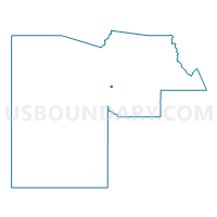
ROADRUNNER Voting District, Maricopa County, Arizona
About
Outline

Summary
| Unique Area Identifier | 524264 |
| Name | ROADRUNNER Voting District |
| County | Maricopa County |
| State | Arizona |
| Area (square miles) | 0.99 |
| Land Area (square miles) | 0.99 |
| Water Area (square miles) | 0.00 |
| % of Land Area | 100.00 |
| % of Water Area | 0.00 |
| Latitude of the Internal Point | 33.50217430 |
| Longtitude of the Internal Point | -112.16021860 |
Maps


Graphs
Select a template below for downloading or customizing gragh for ROADRUNNER Voting District, Maricopa County, Arizona


Neighbors
Neighoring Voting District (by Name) Neighboring Voting District on the Map
- ALHAMBRA Voting District, Maricopa County, AZ
- CANAL Voting District, Maricopa County, AZ
- CRITTENDEN Voting District, Maricopa County, AZ
- DENTON Voting District, Maricopa County, AZ
- GLENDALE 31 Voting District, Maricopa County, AZ
- MARYVALE Voting District, Maricopa County, AZ
- PIERSON Voting District, Maricopa County, AZ
Top 10 Neighboring County Subdivision (by Population) Neighboring County Subdivision on the Map
Top 10 Neighboring Place (by Population) Neighboring Place on the Map
Top 10 Neighboring Elementary School District (by Population) Neighboring Elementary School District on the Map
- Cartwright Elementary District, AZ (112,047)
- Alhambra Elementary District, AZ (84,491)
- Isaac Elementary District, AZ (43,107)
Top 10 Neighboring Secondary School District (by Population) Neighboring Secondary School District on the Map
Top 10 Neighboring State Legislative District Lower Chamber (by Population) Neighboring State Legislative District Lower Chamber on the Map
Top 10 Neighboring State Legislative District Upper Chamber (by Population) Neighboring State Legislative District Upper Chamber on the Map
Top 10 Neighboring 111th Congressional District (by Population) Neighboring 111th Congressional District on the Map
Top 10 Neighboring Census Tract (by Population) Neighboring Census Tract on the Map
- Census Tract 1094, Maricopa County, AZ (8,290)
- Census Tract 1099, Maricopa County, AZ (7,080)
- Census Tract 1101, Maricopa County, AZ (6,612)
- Census Tract 1071.02, Maricopa County, AZ (5,197)
- Census Tract 1093, Maricopa County, AZ (4,670)
- Census Tract 931.01, Maricopa County, AZ (4,547)
- Census Tract 931.04, Maricopa County, AZ (4,385)
- Census Tract 1100.02, Maricopa County, AZ (4,339)
- Census Tract 1092, Maricopa County, AZ (4,096)